NASA's TEMPO Satellite: Revolutionizing Air Quality Monitoring Across North America
In an unprecedented leap forward for environmental science and public health, NASA's TEMPO (Tropospheric Emissions: Monitoring of Pollution) satellite is transforming the way we understand and combat air pollution. A collaborative mission involving NASA, the National Oceanic and Atmospheric Administration (NOAA), and the Smithsonian Astrophysical Observatory, TEMPO has been delivering groundbreaking hourly, high-resolution pollution data from space across North America since its launch in 2023. This mission is slated to continue its vital work until at least 2026, with the potential for extensions, promising a new era of actionable insights into atmospheric chemistry.
Table of Contents
- Introduction: A New Vantage Point for Air Quality
- What is TEMPO? Mission and Collaboration
- How TEMPO Works: The Technology Behind the Data
- Unprecedented Data Resolution and Coverage
- Impact on Public Health and Policy Making
- Supporting Climate Research and Atmospheric Modeling
- Data Accessibility and Real-World Applications
- Challenges and Future Outlook of Remote Sensing
- TEMPO in a Global Context: A Blueprint for the Future
- Conclusion: Breathing Easier with Satellite Science
Introduction: A New Vantage Point for Air Quality
For decades, monitoring air pollution has primarily relied on ground-based sensors, which, while crucial, offer limited spatial coverage and often lack the ability to track the rapid changes in atmospheric composition. The launch of the TEMPO satellite marked a pivotal shift, ushering in an era of continuous, real-time monitoring of major air pollutants over North America. Positioned in a geostationary orbit, TEMPO provides an unparalleled perspective, capturing hourly snapshots of pollutant concentrations from Mexico City to the Canadian oil sands and from the Atlantic to the Pacific coasts. This capability is not merely an incremental improvement; it is a fundamental transformation in our ability to observe, understand, and respond to the dynamic nature of air pollution.
The mission's innovative design allows scientists to track the daily ebb and flow of pollution, pinpointing sources, observing chemical transformations, and monitoring the effectiveness of mitigation strategies. This constant vigilance is indispensable for urban planners, health officials, and environmental agencies striving to safeguard public health and promote cleaner air. The data from TEMPO serves as a critical resource, empowering communities with the knowledge needed to make informed decisions about air quality and its profound impact on human well-being and ecosystems.
What is TEMPO? Mission and Collaboration
TEMPO is more than just a satellite; it is a testament to international scientific collaboration and technological ingenuity. Led by NASA, with significant contributions from NOAA and the Smithsonian Astrophysical Observatory, the mission brings together diverse expertise to address one of the planet's most pressing environmental challenges. The primary objective of TEMPO is to measure tropospheric pollutants, including nitrogen dioxide (NO2), ozone (O3), formaldehyde (HCHO), and sulfur dioxide (SO2), as well as aerosols, with unprecedented spatial and temporal resolution.
The instrument itself was built by Ball Aerospace & Technologies Corp. and is operated by the Smithsonian Astrophysical Observatory. This partnership ensures that the data collected is scientifically rigorous and readily accessible for a wide range of applications. NOAA, a key partner, leverages TEMPO data for operational weather forecasting and air quality alerts, integrating space-based observations into daily public advisories. The collaborative spirit behind TEMPO echoes other significant space endeavors, such as the regular resupply missions to the International Space Station. For instance, the recent successful launch of Russia's Progress 92 Lifts Off: 3 Tons of Crucial Supplies for ISS Astronauts highlights the continuous effort in space-based operations, whether for human exploration or vital scientific monitoring like TEMPO.
The mission's initial operational phase is set to conclude in 2026, but the wealth of data and the critical insights it provides suggest a strong case for continued operation, extending its invaluable contribution to environmental science and public health for years to come. This long-term commitment underscores the urgency and importance of understanding atmospheric changes.
How TEMPO Works: The Technology Behind the Data
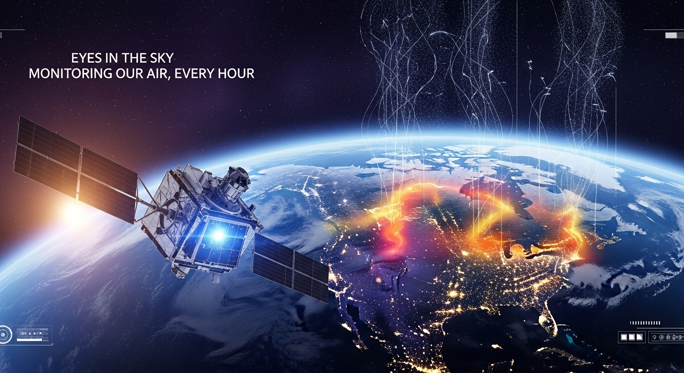
The technological prowess of the TEMPO satellite is what truly sets it apart. Unlike previous low Earth orbit (LEO) satellites that provide only one or two snapshots of a given location per day, TEMPO operates from a geostationary orbit. This means it hovers continuously over the same geographical region, specifically North America, allowing it to collect data at an hourly interval during daylight hours. This capability is revolutionary for tracking rapidly evolving pollution events, such as rush hour emissions, wildfire smoke plumes, or industrial releases.
At the heart of the TEMPO mission is a sophisticated spectrometer that measures reflected sunlight. As sunlight passes through Earth's atmosphere, specific gases absorb certain wavelengths of light. TEMPO's spectrometer detects these subtle absorption patterns, allowing scientists to identify and quantify the concentrations of various pollutants. The instrument can scan the entire North American continent, from coast to coast and from central Mexico to central Canada, approximately every hour.
The high spectral resolution of TEMPO's instrument enables it to distinguish between different gases even when their absorption features are close together. This precision is critical for accurately measuring pollutants like NO2 and HCHO, which are key precursors to ground-level ozone and fine particulate matter, two of the most harmful air pollutants. The data collected by TEMPO is then transmitted to ground stations, processed, and made available to scientists, air quality managers, and the public. The meticulous management of such vast and critical datasets also highlights the importance of robust data security and integrity, echoing principles seen in fields requiring FBI-Level Data Protection: Essential Lessons for Finance & Accounting.
Unprecedented Data Resolution and Coverage
TEMPO's data resolution is truly unprecedented. It provides measurements down to spatial scales of just a few square kilometers, which means it can pinpoint pollution hot spots within cities, identify specific industrial sources, or track the dispersion of emissions from major transportation corridors. This fine-grained detail is invaluable for localized air quality management and for understanding how urban landscapes contribute to regional pollution levels.
The hourly temporal resolution is equally transformative. Previous satellite missions might offer daily or even weekly averages, but these often smooth out critical short-term variations that are crucial for understanding pollutant chemistry and human exposure. With TEMPO, researchers can now observe the diurnal cycles of pollutants, how they build up during morning commutes, disperse in the afternoon, or get transported by winds across state lines. This dynamic view provides a much clearer picture of air pollution's complexities.
Furthermore, TEMPO's broad geographic coverage across all of North America fills a significant gap in global air quality monitoring. While other satellites provide regional coverage (like Europe's Sentinel-5P), TEMPO offers a dedicated and continuous eye over a vast and diverse continent, encompassing a wide range of emission sources from natural wildfires to dense urban centers and agricultural areas. This comprehensive coverage allows for cross-border studies and a holistic understanding of atmospheric processes that transcend political boundaries.
Impact on Public Health and Policy Making
The implications of TEMPO's data for public health are profound. Air pollution is a silent killer, contributing to millions of premature deaths globally each year and exacerbating respiratory and cardiovascular diseases. With hourly, high-resolution data, health officials can issue more timely and accurate air quality advisories, allowing vulnerable populations – such as children, the elderly, and those with pre-existing conditions – to take precautions and minimize exposure during periods of poor air quality.
Moreover, TEMPO data empowers epidemiologists to conduct more precise studies on the links between specific pollutant exposures and health outcomes. By correlating real-time air quality data with health records, researchers can gain deeper insights into the health impacts of different pollutants at localized levels, leading to more targeted public health interventions. This level of detail has been largely unattainable with coarser, less frequent satellite observations or sparse ground-based networks.
For policymakers, TEMPO provides an indispensable tool for evaluating the effectiveness of air quality regulations and clean air initiatives. By tracking pollutant levels before and after the implementation of new policies, authorities can assess their impact directly from space. This evidence-based approach is crucial for developing future strategies and ensuring that environmental protection efforts are yielding tangible results. For example, understanding how emissions from specific regions travel and affect downwind areas can inform interstate air quality agreements and national environmental policies. More details on general environmental regulations can be found on official government sites like the Environmental Protection Agency (EPA) website.
Supporting Climate Research and Atmospheric Modeling
Beyond immediate air quality concerns, TEMPO plays a crucial role in advancing climate change research. Many of the pollutants measured by TEMPO, such as ozone and aerosols, are also powerful greenhouse gases or have significant radiative forcing effects, influencing Earth's climate system. By providing detailed measurements of their concentrations and distributions, TEMPO helps scientists better understand their role in atmospheric chemistry and their contribution to climate change.
The hourly data also aids in improving atmospheric transport and chemistry models. These models are vital for predicting future air quality, understanding long-range transport of pollution, and forecasting climate trends. TEMPO's high-resolution observations allow for the validation and refinement of these complex models, leading to more accurate predictions and a more robust understanding of Earth's atmosphere. This integration of observational data with predictive modeling is essential for developing effective strategies to address both air pollution and climate change.
The ability to track the movement of pollutants, including those originating from large industrial areas or natural events like wildfires, offers unprecedented opportunities for scientists. It allows them to differentiate between local emissions and transported pollution, a key factor in formulating equitable and effective environmental policies. This precision supports the broader scientific community's efforts to model and predict the Earth's future climate scenarios with greater accuracy.
Data Accessibility and Real-World Applications
A core tenet of the TEMPO mission is making its invaluable data accessible to a wide audience. NASA and NOAA are committed to providing the data to researchers, government agencies, and the public through various platforms. This open access policy maximizes the utility of the satellite's observations, encouraging innovation and widespread application.
Real-world applications of TEMPO data are already emerging. Air quality forecasting agencies can integrate TEMPO's hourly data into their models to provide more accurate and timely forecasts, enhancing public awareness and preparedness. Researchers are using the data to investigate complex atmospheric processes, such as the formation of ground-level ozone in urban plumes or the contribution of biogenic emissions to regional air quality. Urban planners can utilize the data to identify areas with persistently high pollution levels, informing decisions on infrastructure development, traffic management, and green space planning.
Furthermore, the data holds potential for industries focused on environmental impact assessments and sustainable development. Companies can leverage TEMPO data to monitor their emissions or assess the atmospheric conditions relevant to their operations. This transparency can foster greater accountability and drive cleaner practices. The sheer volume and speed of data transmission and processing required for missions like TEMPO echo the advancements seen in other data-intensive fields, including those that involve sophisticated AI applications, such as the capabilities highlighted in the Air France-KLM's Bots Saved 200,000 Hours: Now Leveling Up with Advanced AI article, where efficient data handling leads to significant operational benefits.
Challenges and Future Outlook of Remote Sensing
While TEMPO represents a monumental achievement, like any cutting-edge technology, it faces ongoing challenges. Ensuring the long-term calibration and validation of the instrument, managing the immense volume of data generated, and translating complex scientific observations into actionable insights for diverse stakeholders are continuous efforts. The mission also needs to contend with potential data gaps during cloudy conditions, as optical instruments like TEMPO cannot see through thick clouds.
Despite these challenges, the future of satellite-based air quality monitoring looks incredibly promising. TEMPO is part of a larger global constellation of geostationary air quality satellites, including Europe's Sentinel-4 and South Korea's GEMS. Together, these missions will provide a nearly continuous, global view of atmospheric pollution, offering an unprecedented opportunity to study transcontinental pollution transport and global atmospheric chemistry. This integrated approach promises to revolutionize our understanding of the planet's atmosphere and foster international cooperation in addressing environmental challenges.
Looking beyond 2026, the success of TEMPO provides a compelling case for follow-on missions and the continued investment in advanced Earth observation technologies. As the Earth's climate continues to change and urbanization expands, the need for precise, real-time environmental data will only grow. NASA's commitment to such missions remains unwavering, much like its continued involvement in groundbreaking space projects and partnerships with private space companies. The insights gained from TEMPO will undoubtedly influence the design of future satellite missions, pushing the boundaries of what is possible in remote sensing technology. For those interested in the broader landscape of space exploration and investment, understanding the trajectory of advanced space technologies, including those by private entities, can be insightful. For instance, discussions around The End of an Era for Japan's H-2A Rocket; Here's How to Invest in SpaceX touch upon the evolving dynamics of the space industry.
TEMPO in a Global Context: A Blueprint for the Future
TEMPO's success extends beyond North America, serving as a blueprint for future global air quality monitoring initiatives. The approach of deploying geostationary satellites dedicated to hourly pollution tracking over specific continents is a game-changer. As mentioned, Europe has its Sentinel-4 mission and Asia has South Korea's GEMS (Geostationary Environment Monitoring Spectrometer). Together, these satellites form a nascent "virtual constellation" that will eventually provide a near-global, hourly view of air pollution over major populated landmasses.
This coordinated international effort is crucial because air pollution does not respect national borders. Emissions from one country can easily be transported by winds to affect air quality in another. A global network of TEMPO-like satellites will allow scientists to track these transboundary pollution events, understand the global transport of aerosols and gases, and develop more effective, coordinated mitigation strategies. This interconnected view of our atmosphere is essential for addressing what are fundamentally global environmental challenges.
The data from this emerging global constellation will also feed into improved global atmospheric chemistry models, leading to more accurate long-term climate predictions and a better understanding of how human activities are altering the planet's atmosphere on a planetary scale. This holistic view is necessary for informing international climate agreements and setting global targets for emissions reductions. The collaborative nature of these missions underscores the fact that global challenges require global solutions, often facilitated by advanced technological and data-sharing frameworks, much like how various tech companies contribute to AI advancements, as explored in discussions around Meta Raids Ilya Sutskever's AI Startup, Poaching Its CEO Amid Talent Battle.
Conclusion: Breathing Easier with Satellite Science
NASA's TEMPO satellite represents a monumental leap forward in our capacity to monitor and understand air pollution. Its hourly, high-resolution measurements across North America are providing unprecedented insights for researchers, invaluable tools for health officials, and critical information for the public. By offering a dynamic view of atmospheric chemistry, TEMPO is empowering us to make more informed decisions, implement more effective policies, and ultimately, breathe easier.
As the mission continues its operations, its legacy will undoubtedly extend far beyond 2026. It is not merely collecting data; it is fostering a deeper understanding of our planet's atmosphere, bridging the gap between scientific observation and actionable environmental management. TEMPO stands as a powerful testament to human ingenuity and our collective commitment to safeguarding the health of both people and the planet, one hourly measurement at a time. For more information on NASA's missions and Earth observation projects, you can visit the official NASA website or NOAA's environmental data portal.